After our sojourn through the Chilean fjords, Ben and I did the W Trek, in Torres Del Paine. This is a 5 day, 4 night hike. There are a few options when hiking through the Torres Del Paine:
- the O Circuit – this is the most epic option, usually takes between 8 and 10 days (for the very fit hiker), and you can do a combination of refugios and camping;
- the W trek – can be done as a 5D4N (which is what we did), or a 4D3N; and
- Day hikes – you can stay in Puerto Natales and take the 2.5 hour (each way) bus up to Base Central, and hike up to Torres Central and back, and the next day you can take the bus and ferry to and from Paine Grande to hike up to Grey Glacier and back. So there’s at least 2 really good hiking days right there.
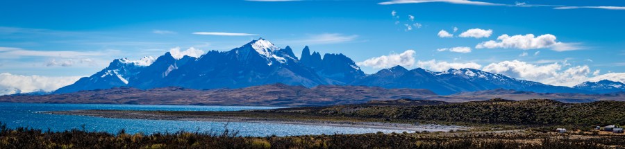
Here’s a picture so you can see what I am talking about:

Puerto Natales is basically a launching platform for the Torres Del Paine. Everywhere you turn, there is something related to hiking. Hiking-related stores, hiking tour companies, even the hostels cater to hiking! Most of the hostels let you leave your bags (free of charge) at the hostel while you go on your hike. I think it’s a really great idea, as you can’t really take all your crap with you on the hike.
We stayed at Hostel El Sendero the night before and the night after the hike – it was a hostel, but it was clean and really good value for USD$45 per night. Juan, the owner, was a really awesome dude, and he had great advice for us. I was especially terrified, as this was my first hike, let alone overnight!
The night before the hike, we attended a quick briefing with Fantastico Sur, who organised our big hike. There we met our fellow Australians, Malcolm and Evelyn from Melbourne! We were so excited to meet them, and we were going to be doing the hike together. Malcolm and Evelyn are experienced hikers, and they eased a lot of my fears.
- arrived at Torres Del Paine around 5.30pm.
- Did a short 7km walk to the lake nearby – Lago Norddernskjold.
- Dinner was surprisingly good. Plenty of vegetables, vegetable lentil soup, pork loin with pumpkin purée and rice pudding.
- We met Marko and Amandine, from Paris. Marko is a really great guy, he speaks English really well. Amandine is very quiet, although this could be due to the fact that she does not speak English. They are both really lovely, and have promised to show us their Paris when we go to visit someday.


- route: Refugio Torre Central – Los Chilenos – Torres Ranger Station – Miradora Las Torres (return)
- Time taken to complete: 10 hrs 15 minutes
- Our combined Fitness levels: below average
- Distance: 20.3km (round-trip)
- Elevation: from 134m to 880m to 134m
- Weather: beautifully sunny and hot, not a cloud in the sky, unbearably hot by 12pm. I had stripped down to my sports bra by 9am.
- This was a really hard first day. We started our hike at precisely 8am. The path was flat for about 45 minutes. Then we began the first steep section to get up to 485m elevation. This took about 45 minutes. I really struggled with this, and there was a lot of stopping.
- Another 30 minutes of small ups and downs, then we arrived at Los Chilenos, at 373m elevation. Los Chilenos is a camping ground. It has a beautiful river running through it.
- We walked along the river for a bit, crossed a couple of bridges, walked through a lovely cool forest while continuing to ascend to 600m elevation. This took 1 hr and 30 minutes.
- Then the serious climbing starts. We climbed 300m elevation in 1km of distance. The path was really rocky and challenging. This took 1 hr and 30 minutes of consistent up. It felt like there was no end to this path, the sun was beating down our backs and everyone we passed kept telling me that we are so close to the mirador and yet it seemed like all of them were lying.
- Finally made it to the mirador, and it was really beautiful to see the 3 towers over the aqua lake, and dip my poor tired feet into the bone chilling water. We had our lunch while looking at this spectacular view. The 3 towers were originally a glacier. However, the glacier has since receded and all of the ice has melted which has turned into the lake that we see today. The ice has carved these 3 beautiful towers.
- Heading back down was really tough on my knees. If I thought up was hard, I had no idea what I was in for with down. I slipped so many times and had to crawl on my butt to lower my centre of gravity, and so many people helped me every time I fell. They were really lovely. Once we got past Los Chilenos, the track improved, and it was smooth sailing from then on.
- Arrived at the Refugio at 6.15pm.
- We saw an Andean fox on our way back to Torre Central. He was following me just a metre behind.
- Refugio Torre Central:
- Pros: clean showers and toilets, great meals, clean beds with blankets and pillows. Staff were very attentive.
- Cons: sink taps were very odd. Showers and toilets were outdated, but clean.


- route: Refugio Torre Central – Lago Inge – Lago Norddernskjold – Los Cuernos
- Time taken to complete: 5 hrs 30 minutes
- Our combined Fitness levels: below average
- Distance: 13km
- Elevation: from 134m to 257m to 73m
- Weather: beautifully sunny and hot, not a cloud in the sky, unbearably hot by 10am.
- Our mission for today was to walk from Torre Central to our new Refugio, Los Cuernos. The map we were given said this would be an easy walk, just 11km, easily traversed in 4.5hrs. They lied. It took us 5.5hrs, started at 8.15am, finished at 1.45pm. We also had our bags on our backs. Ben carried 18kg, I carried 6kg.
- It was a stunning walk. We crossed multiple waterfalls, streams and creeks, and we refilled our bottles a couple of times at the waterfalls. Then we ended up with the Lago Norddernskjold on our left side for about 2.5hrs of the walk, which was simply stunning. The water was so beautifully turquoise blue and the mountain ranges were mirrored in the still lake. It was an absolute pleasure to walk along it, even though it was a real struggle with the heat! There was one section that was really steep, Ben and I both had to stop and rest to make it up all the way.
- It was really challenging as we approached Los Cuernos. It is not visible until the last second, as it is nestled into the base of the mountain range, and you have to go fully around the mountain to get to it. So we had to climb up, only to go very down very quickly, and then pass through some very precarious rocky sections to access the Refugio. Finally we are here, and we have made some very nice friends with Francoise and Dagma, who are French and Belgian.
- Refugio Los Cuernos:
- Pros: the food was very good.
- Cons: very rocky descent to arrive at the Refugio. Toilets were not very clean, showers were useable but not cleaned as frequently as other Refugios. It was very sunny and hot when we stayed here, and the Refugio is built with wood and glass, it felt like a furnace inside. It was actually cooler outside. The bar was completely overrun, they did not have enough staff for the number of patrons requiring service. Beds had sleeping bags on them.


- route: Refugio Los Cuernos – Refugio Domos Frances – Campos Italianos – Mirador Frances – Campos Italianos – Refugio Domos Frances
- Time taken to complete: 8 hrs 15 minutes
- Our combined Fitness levels: below average
- Distance: 13km (+5km for Ben)
- Elevation: from 73m to 500m (to 740m for Ben) to 75m
- Weather: beautifully sunny and hot at times, cloudy other times.
- Started at 6.45am, arrived at Domos Frances at 8.30am – 1 hr 45 mins. Rested for 15 minutes. Departed at 8.45am, arrived at Campos Italianos at 9.25am – 40 minutes. Departed at 9.35am, arrived at Mirador Frances at 11.05am – 1 hr 30 mins.
- The first part of the morning from Los Cuernos to Domos Frances went surprisingly well. We zipped through within 1 hr and 45 mins, the map said it would take us about 2 hours. There was a lot of up, but the track wasn’t as bad as I thought it would be. The challenge came as we were heading up to Mirador Frances, to the first lookout point. Man, it was so so hard. I have really struggled with the rocky areas, and this particular section was no exception. The trails here are not very good. The rocky sections are made up of inconsistently sized rocks, and often, where you place your foot is not a stable spot. It’s really hard on your knees, both up and down. On our way up to Mirador Frances, we passed by the Glacier Frances, which is melting, and forms a very large river/waterfall.
- Ben continued on to Mirador Britanico, while I hung out at Mirador Frances. I had lunch and lounged. Ben ran all the way up, if you walk it, it should take you about 3 hrs return, Ben returned to me in 1 hr and 15 mins!
- Sadly, in the end, both of us had buggered our knees, my left and Ben’s right.
- Refugio Domos Frances:
- Pros: easily the best Refugio we have stayed at. The shower was so beautifully clean, the sinks and toilets were pristine. The food was fantastic. It is a smaller Refugio, but it was so nice and cosy, and each Domo had its own wood fire heater.
- Cons: this Refugio is located just by the water, so it is quite a ways down from the main path. Be prepared for some steep ups and some epic downs.


- route: Refugio Frances – Campos Italianos – Refugio Paine Grande – ferry through Lake Pehoe – bus from Pudeto to Puerto Natales
- Time taken to complete: 3 hours
- Our combined Fitness levels: below average
- Distance: 10.5 km
- Elevation: from 75m to 50m
- Weather: windy, rainy, overcast.
- surprisingly easy trail, the path was really good, mostly clear of rocks. Hardly any ups, mostly flat and down, which we were able to do at a jog. We passed by Lake Pehoe along the way, it was a darker blue colour. In the end, we decided not to hike up to Grey Glacier and finish the W trek. Ben and I both weren’t doing so well with our busted knees, so we ended up doing a demented “U-trek”. It was such a relief to finally reach the pier and board the catamaran to civilisation.


I really couldn’t have done this without Ben. He took such good care of me. He helped me down all of the rocky bits, he carried my bag with all my stuff for me, he fetched water for me. He really is a gem.
I learned a lot about myself during this hike. Firstly, I had not prepared enough for the epic-ness of this hike. Secondly, I am definitely into glamping, and I would rather not do another hike that requires more than one night in the wilderness. I did enjoy this hike, the views were beautiful, and it was really challenging, but I don’t think I am a serious hiker. More like a hike dabbler 🙂
Food recommendations:
- La Disqueria, Puerto Natales, Chile – simply amazing! After that huge hike, this dinner was really rewarding. Their specialty are these plough dishes – each is probably big enough for two, but we were so hungry after all that hiking, we ordered one each! I had the king crab fettuccine (the pasta and the crab were so fresh and delicious) and Ben had the steak, peas and potatoes cooked in beer. Can’t believe we managed to finish it all! CLP33,000.


Wow! I don’t know if I like the views, the food or your abs the most 😛
LikeLike
It’s just the one ab!
LikeLiked by 1 person
😂😂😂
LikeLike